10Lines
10LINES · Pavement marking · Shipping since 2021
Last updated: 2026-04
Summary
The 10Lines is a compact, GNSS-guided pavement marking robot that autonomously stripes parking lots from digital site plans. It handles line striping, retroreflective glass bead application, and pre-marking layout for thermoplastic crews; road, highway, and airport marking remain outside documented capability. The robot has been shipping since 2021 out of Estonia, with production deployments in Estonia and limited early presence in the United States.
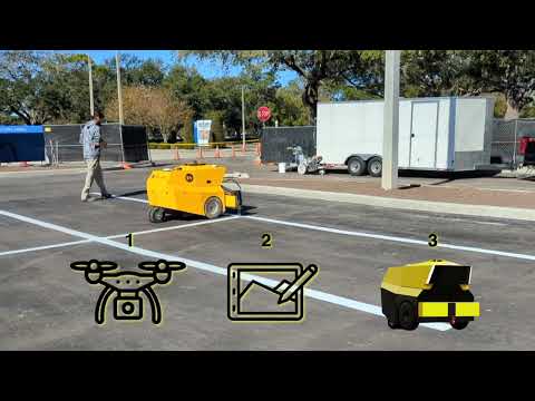
How it works on your site
Parking Lot Line Striping
The robot follows pre-loaded digital site plans and stripes parking lots without a separate manual premarking pass. Galileo satellite positioning guides the chassis directly to each line segment. The crew handles thermoplastic work, signage, and any areas outside the robot's operating envelope.
Layout and Measurement
The robot sprays layout reference lines onto pavement that guide human thermoplastic crews in subsequent passes. An off-the-shelf drone captures site imagery, which is stitched into a digital model and imported into the 10Lines planning software. Job templates are savable and reusable for repeat parking lots.
Retroreflective Bead Application
The robot dispenses reflective glass beads as part of its striping pass, combining marking and retroreflective application into a single automated operation. The crew handles thermoplastic bead application separately.
How it worked on other sites
Unnamed South Florida contractor , Parking lot jobs
Vendor mention- Ongoing production deployment; contractor described as "regularly completing jobs" with the robot.
SOL Baltics (SOL Parkingline) , Parking lot marking
- Long-term client operating the robot for parking lot marking in Estonia.

Miami showcase demonstration
Vendor mention- Two-day demonstration event (February 2023, Miami, FL).