CivDot
Civ Robotics · Layout and marking · Shipping since 2021
Last updated: 2026-04
Summary
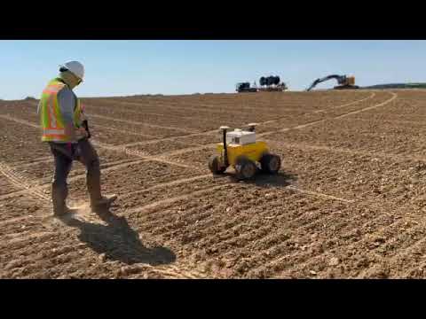
The CivDot is a battery-powered, 4WD compact rover that autonomously navigates outdoor construction sites and marks survey-point positions using spray paint (CivDot standard) or laser indication (CivDot+). It handles site-level horizontal layout for utility-scale solar pile staking using GNSS RTK corrections from Trimble, Topcon, or Leica base stations; fine-tolerance interior layout, vertical work, and complex survey tasks stay with the crew. CivDot has been shipping since 2021 and is deployed across 12 confirmed projects.
How it works on your site
Site-Level Horizontal Layout
CivDot navigates a route-optimized path between uploaded CSV coordinates; CivDot standard sprays paint at each position autonomously while CivDot+ indicates the point with a laser for the operator to place a physical marker. One operator runs the robot from up to 100 feet away, and a single operator can manage two CivDot units simultaneously using the pause-at feature. The robot generates topographical as-built overlays as a byproduct of the layout pass.
How it worked on other sites
Signal Energy, solar pile layout
Utility-scale solar · Location not disclosed
- Solar pile layout across utility-scale solar projects.
- 50% cost reduction reported against manual survey crew (vendor case study).

Qcells, <200 MW solar project (CivDot+)
Utility-scale solar · Location not disclosed
- Solar pile layout performed using CivDot+ model.
- Costs reduced to one-third of previous staking expenses (vendor case study).

Mortenson at Edwards & Sanborn Solar + Storage
Utility-scale solar · California (inferred) · Ongoing (multi-project)
- Solar pile coordinate layout across approximately 400,000 pile positions.
- Ongoing multi-project engagement.

Robot also used by