CivDot+
Civ Robotics · Layout and marking · Shipping since 2021
Last updated: 2026-04
Summary
The CivDot+ is a compact, wheeled, GNSS-based layout robot that autonomously navigates to uploaded coordinates and marks each point with a laser pointer while a single operator monitors from up to 100 feet away. It handles site-level horizontal layout across solar, concrete foundation, LNG, and heavy civil projects; vertical layout, interior work, and BIM-based layout stay with the survey crew or other systems. The CivDot+ has been shipping since 2021 with 13 confirmed production deployments across the United States and Spain.
How it works on your site
Site-Level Horizontal Layout
The robot drives autonomously between uploaded coordinate points on a 4WD chassis with 10 inches of ground clearance, marking each location with a laser pointer. One operator manages the mission from CivPlan software after uploading a CSV or DXF file; no surveying experience is required to run the robot. The crew follows behind to place physical markers at each laser-indicated point.
How it worked on other sites
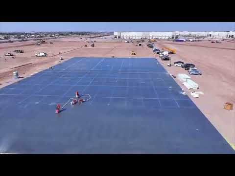
VEMAC, concrete foundation layout
Commercial concrete/tilt-up · USA · 10-15 active projects
- Foundation and tilt-up panel layout across 10-15 concurrent projects.
- Operator trained in under one hour with no prior surveying experience.
Bechtel, Port Arthur LNG wick drain
Industrial LNG · Port Arthur, TX · Wick drain installation
- Wick drain installation point layout on uneven LNG site terrain.
- 4WD chassis and 10-inch ground clearance handled mud and rock conditions.

QCells, utility-scale solar stakeout
Renewable energy solar · USA · Solar pile stakeout
- 700 stakeouts per day with a single operator (vendor case study).
- Operating at one-third of previous surveying expenses (vendor case study).

Robot also used by