Doxel
Doxel · Inspection · Shipping since 2018
Last updated: 2026-04
Summary
Doxel is a cloud-based construction progress tracking platform that uses computer vision to analyze 360-degree video captured during site walks, comparing actual work-in-place against BIM to measure percent complete across 85+ stages of construction. It covers daily walkthrough documentation, BIM-to-field comparison, and defect identification across architectural, structural, MEP, fire-protection, and other visible trades. Doxel has been shipping since 2018 and has five confirmed production deployments across data center and healthcare projects in the United States.
How it works on your site
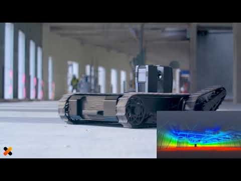
Daily Walkthrough and Progress Documentation
A crew member walks the site wearing a hard hat with a mounted Insta360 camera; the platform processes the resulting video, identifies installed elements, and generates progress reports without pre-mapping or BIM modifications. The rules of credit engine converts field observations into percent-complete figures weighted by effort per trade rather than by element count.
BIM-to-Field Comparison (Scan-vs-BIM)
The platform overlays 360 video captures onto the project BIM using proprietary vision-based SLAM that maps camera position to BIM coordinates. It flags deviations between scheduled and actual progress at the activity level, measuring quantities installed and production rates for every trade and system.
Defect Identification and Punch List / Closeout Tracking
The platform's computer vision identifies installed elements and flags work that deviates from the BIM model or schedule sequence. VSLAM spatial tracking maps each 360 video frame to its BIM location, so identified issues carry coordinate context. Drone footage extends tracking to exterior and underground utilities work.
How it worked on other sites
Kaiser Permanente Viewridge Medical Office
Healthcare · San Diego, CA · Quality inspection and cost tracking (~2018-2019)
- 38% productivity increase and 11% under budget on the Viewridge project.
- Deployed for quality inspection, quantity measurement, and real-time productivity feedback.
- Results from the earlier LiDAR robot; not replicated on the current 360-camera product.

Corscale data center
Data center · Gainesville, VA · Progress tracking and schedule acceleration
- Production deployment for automated progress tracking, schedule acceleration, and waste reduction.

Stream Data Centers enterprise-wide
Data center · Dallas, TX (HQ); nationwide · Enterprise agreement since August 2025
- Enterprise-wide agreement for real-time progress tracking and automated reporting.
- Ongoing engagement covering bottleneck identification and component visualization.
Robot also used by