Robot Plotter
Tyker (Tyker Construction B.V.) · Pavement marking · Shipping since 2018
Last updated: 2026-05
Summary
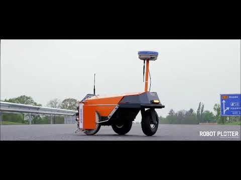
The Robot Plotter is a 21 kg wheeled robot that autonomously marks lines and survey points on road surfaces, airport pavements, and tunnel floors from pre-loaded digital drawings. It covers layout and measurement within the roads and pavements job, using RTK-GNSS or Total Station positioning to execute marking patterns while one operator supervises from outside the active work zone. The Robot Plotter has shipped since 2018 from the Netherlands, with 18 documented customers across four countries and distributors in seven.
How it works on your site
Layout and Measurement
The Robot Plotter loads a DXF drawing, locks onto RTK-GNSS or Total Station positioning, and drives the marking pattern autonomously while the operator stays off the road surface. A drilling module (optional, launched February 2023) handles borehole reference marking on concrete; the base unit handles paint lines on asphalt and tunnel floors. The survey crew's exposure to active traffic is eliminated for premarking tasks.
How it worked on other sites
Winslow at Sunbury Road Upgrade
Vendor mentionRoad construction · Sunbury, Victoria, Australia · Ongoing (project completion target 2025)
- Production deployment for line marking and survey point marking on a state road upgrade.
- One operator marked 1 km in 15 minutes, against 2 hours by the traditional survey method.
Heijmans on A12 Highway Major Maintenance
Road construction · A12, Utrecht, Netherlands · 4 weekends
- Steering line layout and road marking premarking across approximately 10 km of markings.
- Five Road Profilers operated simultaneously during the deployment.

Ballast Nedam / DIBEC at A24 Blankenburgverbinding Tunnel
DIBECTunnel construction · Rotterdam, Netherlands · Multi-phase
- 280,000 boreholes marked and drilled using Total Station mode and the drilling module.
- Scope included borehole marking, rebar placement marking on underwater concrete, and 3D laser scanning integration.
Robot also used by